Local Walks
There is a wonderful network of footpaths in and around our parishes and quite a few local booklets. The Worcestershire Way goes through Shelsley Beauchamp and Clifton has a very famous walk through Paradise!
A Walk Through Paradise.
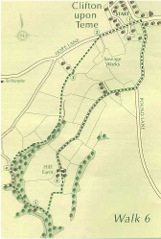 This walk goes along the western side of a deep little valley known locally as Paradise, returning on its eastern side through Hill Farm.
Distance: 2.8 miles or 4.5km.
1. Leave the village of Clifton-upon-Teme along Hope Lane, signposted to Harpley. About 400 metres down there is a finger post at the start of a track leading to the sewage plant.
2. Cross the stile into the paddock to the right of the track. The path runs diagonally left to a stile in a fence and then in the same line to the bottom left corner of the field, to the left of a shed. Cross a stile in a wire fence and go on to a stile in the corner.
3. The path then follows the valley of the brook on the left through five fields, by gates and a stile. There is a stile in the fence at the bottom of the fifth and the path then goes to the left down a steep slope through a coppice to the lane.
4. Turn left down the lane over a stone bridge and up as far as a private parking place at the bend. Steps alongside lead down to a path, which turns right then left to cross a footbridge. Turn right above Sapey Brook, reaching Waste Common about 1 km from the road.
5. Go to the left of the cottage and climb a steep slope until you see a field gate on your left. Look to the left of the gate and you will see another farther up the slope. Go through this gate, leaving the track. Follow the fence on your right to a corner, then go diagonally right to a gate in the top right-hand corner of the field. Continue up to the farm.
6. Pass between the house on the right and the farm buildings on the left to the farm road ahead, which leads to Pound Lane. The eastern side of the dell is now in view. Turn left up Pound Lane to the village.
Clifton Hill Walk
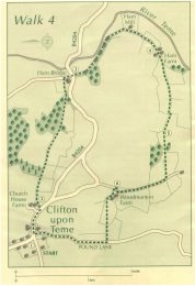 This walk goes to the east of the village, down Clifton Hill, along the River Teme to Ham Farm, and from there climbs gently back up to the village past Woodmanton Farm.
Distance: 5 miles or 8km.
1. From the village green in Clifton-upon-Teme, leave the village along the main road to Martley (past the church). Turn left into the second entrance to Church House Farm. Cross the yard, then turn right round a pond to a track in front of a fence and hedge.
2. Turn right along the track through four fields, going downhill, to reach a strip of woodland. Bear left through it to a bridlegate in a fence at the bottom left-hand corner. Continue down the next field for about 300 yards to a bridlegate into the wood on the left. Turn right down the track, then at the bottom turn left, cross a stream, and go up the slope to a bridlegate. Bear right and follow the hedge and fence down to the road. Turn right to the T junction near Ham Bridge.
3. Cross the main road to a farm lane opposite. This leads to Ham Farm. On the left, on a bend, is Ham Mill. At the entrance to the farm, pass between farm buildings and then two gates. Beyond these, turn right, passing on the left a brick barn and a half-timbered and stone house.
4. The track bears left. Go through a gate, then uphill alongside a wire fence on your left. At the tope of the rise, continue straight ahead, with the hedge on your left, for over half a mile to another gate. Go straight ahead, with a wire fence on your right, until it turns right. There is a waymarker by the corner post.
5. Another footpath goes to the right here, but continue straight ahead uphill past the corner of a wood on your right to a bridlegate in the hedge at the top. From the gate, continue straight ahead to the end of a hedge in front of you and go down it, with the hedge on your right, to a stile on to the drive top Ayngstree. Turn right along it through two fields to Woodmanton. Follow the road over a cattlegrid and round some farm buildings.
6. The road continues straight ahead but take a concrete road on the left through the farmyard between metal buildings. The farm house is to the left. Bear diagonally right through a paddock to two gates. Both are waymarked but go through the left one and straight down the field on a line midway between a line of trees on the right and a telegraph pole to the left, visible at the bottom of the field. This should bring you to a stile and a bridge. The path continues down the right-hand hedge to Pound Lane, opposite Salt Box cottage. Turn right up Pound Lane to the village.
